
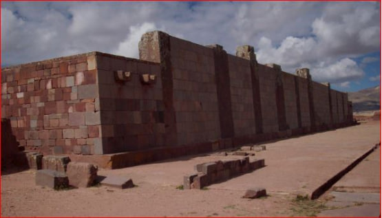
This photograph captures the iconic eastern entrance to the Kalasasaya complex at Tiwanaku (also spelled Tiahuanaco), a major pre-Columbian archaeological site and UNESCO World Heritage location in Bolivia. The precisely constructed reddish stone gateway, accessed by a monumental staircase, frames a standing monolith (the Ponce Monolith) in the background. The lower walls are adorned with characteristic carved stone heads protruding from the masonry, a hallmark of Tiwanaku architecture. The scene highlights the site's advanced stonework and astronomical alignments, set against the high-altitude Altiplano landscape.
The Story of the Tiwanaku Civilization
0


Andy Ray
The author of the Uncharted Planet section is an architect and artist, a traveler and researcher, and a proponent of alternative history. Combining professional architectural insight with visual thinking and field observations, he explores ancient civilizations, enigmatic structures, and traces of knowledge that do not fit into widely accepted historical narratives.
Tiwanaku is an archaeological complex made up of the ruins of the central city of an ancient civilization that once flourished here. According to the mainstream historical timeline, that civilization existed from roughly the 15th century BCE to the 12th century CE. Some alternative historians, however, argue that Tiwanaku—like many other sites linked to a highly advanced “proto-civilization”—is far older. In that view, the culture is sometimes described as “pre-flood,” with the cataclysm dated to around 10,000 BCE.
Today, Tiwanaku sits in Bolivia on the high-altitude Altiplano plateau, about 4,000 meters (13,000 feet) above sea level, not far from modern-day Lake Titicaca.
A City That Shouldn’t Be This Heavy
Even today, one big question still hangs in the thin air up on the Altiplano: how did this ancient people manage to build such massive stone structures at this elevation? Some individual blocks weigh more than 400 tons. Just as mysterious are the reasons behind Tiwanaku’s decline—but let’s try to untangle at least part of the story.
Buried for Centuries, Marked by Stone Gateways
For a long time, the entire Tiwanaku complex lay buried beneath a thick blanket of soil. Above the ground, only enormous stone gateways rose like silent markers. We know the city was once called Taypikala—a name from the Aymara language that translates roughly to “the Stone Heart of the World.” Other versions of the city’s original name appear in different sources and traditions. During its height, for example, it was said to be known as Wiñaymarka, or “the Eternal City.” Today, it’s widely called Tiwanaku—sometimes poetically rendered as “the Dead City.”
A Peaceful Powerhouse With No “Neighbors”
One striking feature of the culture is the apparent absence of wars with neighboring peoples. In fact, Tiwanaku may not have had “neighbors” in the usual sense: it drew surrounding groups into its orbit, becoming the cultural, economic, and religious hub of a vast state.
How Big Was Tiwanaku, Really?
Historians still debate the city’s true scale and population. Estimates range from 2.6 to 6 square kilometers (about 1 to 2.3 square miles) and from 20,000 to 40,000 residents. But researchers tend to agree on one point: the city appears to have suffered two major catastrophes—one natural, associated with flooding, and another of unclear origin.
Two Catastrophes: Flood Evidence and a Second Mystery
Evidence pointing to flooding includes the remains of lake vegetation and fish bones found in sediment layers mixed with fragments of human skeletons—people who likely died in the disaster. What’s more, the remains of people and animals were jumbled together with stone slabs, tools, ceremonial objects, and countless everyday items. It’s as if some unknown destructive force swept through and turned the city into a massive, chaotic debris field. And yet, aside from a “great flood,” it’s hard to imagine what kind of inundation could overwhelm a settlement sitting at 4,000 meters (13,000 feet) above sea level.
Waru-Waru: The Ancient “Raised Fields” System
We also know Tiwanaku was an agricultural civilization. Vast areas were cultivated—something that would have required serious knowledge and planning. But today, the landscape around Lake Titicaca isn’t especially friendly to farming, and much of that ancient know-how has been lost.
In the 1960s, researchers finally began to understand the purpose of the long ridges and narrow canals crisscrossing the terrain. Known locally as waru-waru, they turned out to be part of an intricate, ancient agricultural engineering system. According to legend, it was a gift from the gods to the people of Tiwanaku.
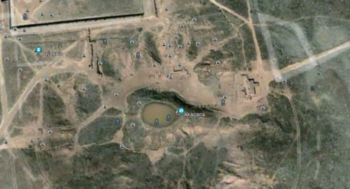
The ancient agricultural complex is now often referred to as “raised fields.” Around the lake, Indigenous communities built man-made earthen platforms, irrigated through a network of canals.
The Inca Arrive—and Rename a Forgotten City
Tiwanaku got its current name from the Inca, because by the time they arrived, the city’s original name had already been forgotten. Before the Incas reached Lake Titicaca, these lands were said to belong to the “people of Tiwanaku,” though it’s still unclear who they truly were—where they came from, and where they went. Near the ruins, there were Inca houses, suggesting the site remained important long after its peak.
A Spanish Witness: “It Appeared Overnight”
Even the Spanish conquistadors were stunned by the grandeur of Tiwanaku’s remains. The chronicler Pedro Cieza de León wrote that he asked local residents whether these structures were built during the Inca era—but they laughed and told him they were far older. According to what they’d heard from their ancestors, everything visible there had appeared suddenly—overnight.
Pedro Cieza de León was a Spanish priest and soldier, a humanist, historian, and geographer, and one of the earliest chroniclers to write about the conquest of South America. He personally crossed the territories of what are now Colombia, Ecuador, Peru, Bolivia, and Chile—more than 7,000 kilometers (over 4,300 miles) of travel.
Here’s how Cieza de León described Tiwanaku in his writings, in essence: he could say much more, but he believed Tiwanaku to be one of the most ancient places in the region. He noted that some similar structures were said to predate the Inca rulers, and that he’d heard Indigenous accounts claiming the Incas modeled certain large buildings in Cusco on a wall preserved at this site. Some even said the earliest Incas intended to establish their court at Tiwanaku.
He also pointed out something else that struck him as important: in the surrounding area there are very few cliffs or quarries where such an enormous quantity of stone could have been cut. Transporting those blocks, he reasoned, would have required huge numbers of people. When he questioned locals again—this time in the presence of Juan Varagas, who held an encomienda there—they insisted the buildings were constructed before the Incas, but they couldn’t say by whom. They only repeated what they’d heard from elders: that it had all been made in a single night.
And finally, Cieza de León added one more rumor he’d encountered: that bearded men had been seen around Lake Titicaca, resembling those said to have built another structure elsewhere. Based on that, he speculated that before the Incas there may have been a small group of capable, unknown people who arrived from who-knows-where, accomplished what he’d described—and were later wiped out in wars, overwhelmed by much larger local populations. Reflecting on how fragile memory can be, he ended by praising the invention of writing for preserving accounts of what happens in the world.
If you want, I can also do a tighter, more bloggy version of this section (same meaning, fewer “academic” sentences) so it reads even more like a Wandered-style travel story.
Akapana: The Sacred Mountain Everyone Calls a Pyramid
The main structure of the Tiwanaku complex is the sacred Akapana—often translated as “the place where people die.” Calling it a “pyramid” is a bit of a stretch. It’s essentially a massive earthen mound, with only its lower tier faced in stone.
For the Tiwanaku civilization, this Sacred Mountain—a temple dedicated to Pachamama, Mother Earth—was the center of the city and, symbolically, the center of the world. The lower slopes are clad in andesite slabs, aligned with the cardinal directions. At the top, there may once have been a cross-shaped basin (that’s one theory). Inside, a complex system of zigzagging stone channels is hidden away—fitted together with almost jewel-like precision, neatly joined and aligned at the corners. Water from the basin was routed into these channels, but what this meticulously built “pipeline” system was actually for is still unknown.
Another interpretation suggests the depression on the summit wasn’t a basin at all, but a crater—evidence, some claim, of a major explosion. Because the site has suffered significant damage over time, the pyramid’s original purpose remains frustratingly hard to pin down.
Kalasasaya: Standing Stones and a Sky-Watching Calendar
Nearby stands the temple of Kalasasaya, often translated as “Standing Stones.” Its walls—built from blocks weighing up to 40 tons—lean slightly inward toward the center of the structure. Many researchers believe it was used for astronomical observations, functioning like a giant stone calendar.
And then there’s one of those details that feels almost too strange to be true: within the temple are openings carved into stone in the shape of a human ear. If you place your ear to one, you can hear voices from surprisingly far away.
Gate of the Sun, Gate of the Moon
Inside the temple you’ll find the Gate of the Sun, carved from a single monolithic block of gray-green andesite. Its entire surface is covered in detailed relief carvings. It’s one of Tiwanaku’s most enigmatic artifacts—alongside the site’s other famous portal, the Gate of the Moon.
Puma Punku: 400-Ton Blocks and Puzzle-Perfect Stonework
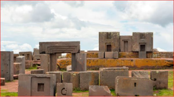
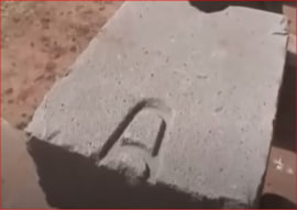
Just as fascinating is the platform built from gigantic stone slabs on the hill of Puma Punku. Some of these blocks are said to weigh up to 400 tons. In the past, they may have served as the foundation for a larger structure, and for extra stability they were connected with specially shaped clamps of different designs. Archaeologists have found several of these clamps—and they turned out to be metal.
The Nickel Mystery—and On-Site Metal Casting
A chemical analysis of one clamp revealed an unexpected detail: the alloy contained around 2% nickel. The catch? Bolivia isn’t known for nickel deposits. So who brought this metal here—and from where, and how?
Researchers have also suggested that these clamps weren’t made elsewhere and then installed. Instead, molten metal appears to have been poured directly into holes and grooves on-site. To do that, you’d need some kind of small, portable smelting setup—almost like a mobile mini foundry.
“Not Just Ruins”: The Feeling of Total Destruction
The stonework itself is equally mind-blowing. The quality of the blocks is so high that whoever shaped them didn’t seem to struggle, even though they were working with extremely hard rock. Many stones have truly unusual forms—niches, protrusions, holes, and precise slots. What they were meant for is still anyone’s guess.
Unfortunately, the site is so heavily damaged that it’s nearly impossible to picture what these structures originally looked like. Much of the main complex is now a chaotic field of rubble, with stones that look as if they’ve been literally torn apart. Puma Punku doesn’t feel like ordinary ruins—it feels like the aftermath of total destruction, as if some incredibly powerful force hit the place head-on… almost like an explosion.
A Cosmic Blast Over Titicaca?
Some scientists have suggested that destruction on this scale could have been triggered by the atmospheric explosion of a cosmic object. Indigenous legends go even further—claiming they can trace not only the trajectory of a large fragment (often described as part of a comet), but even pinpoint the blast location: Lake Titicaca itself.
In this version of events, the shockwave would have been so immense that it sloshed the lake’s waters outward, noticeably lowering the water level and scattering the massive stone blocks that once formed the city’s buildings. A towering surge then raced across the surface of Lake Titicaca like a moving wall of water, crushing everything in its path—and Tiwanaku, the story goes, was wiped out by a terrifying catastrophe.
But Puma Punku Tells a Different Story
But the pattern of damage at Puma Punku includes details that don’t quite fit a “floodwave” explanation. It’s especially noticeable on the platform built from enormous blocks, which looks as if it was hit by something highly localized—more like a direct strike than the broad, sweeping force of water. Some even argue you can make out an “impact center” from the shattered slab at the platform’s core.
Meteorite Theory—and the Problem With It
What do you think of these theories? Doesn’t any of it feel strangely familiar?
Another explanation that comes up is a meteorite impact. But here’s the thing: in the Cusco Valley you’ll find plenty of sites with the same kind of “torn apart and scattered” stonework. There’s the blasted-looking temple at Sacsayhuamán, the shattered remains at Qenqo, and the tower ruins at Sillustani. These places show signs of what looks like deliberate, targeted destruction. It doesn’t read like an earthquake—and even a heavy meteor shower would have a hard time hitting so many separate locations in such a similar way.
Akapana’s Crater: One More Uncomfortable Clue
And as I mentioned earlier, on the summit of the so-called Akapana “pyramid” there’s a massive crater-like depression, with enormous blocks scattered around the edges, mixed into the earth as if something tore straight through the site.
Fire From the Sky: A Chronicle and a Date
In the lesser-known chronicles of Fernando Montesinos, there’s a legend about the destruction of certain “giants.” Divine justice, the story says, wiped them out in a single moment by sending fire from the sky. If you want to look at it through a modern lens—how is that not a description that sounds like a coordinated strike hitting multiple sites at once?
Meteor Storm or “War of the Gods”?
What makes it even more intriguing is the timing: the event is dated to 3,000 years after the flood—roughly 5,000–7,000 BCE—which, suspiciously, lines up with themes found in ancient Sumerian texts and the ancient Indian treatise often referred to as “War of the Gods.” And just like that, we’re back to the same “two catastrophes” idea: one natural (a flood), and a second with an unclear cause.
Was it an intense meteor shower—or something mythic, like a “war of the gods”? I’ll let you decide.
Anyone who reads my articles and then the book (or reads them side by side) will understand what I mean when I say there’s almost no “fantasy” in my novel WAR OF THE GODS. It’s less science fiction and more a thought experiment: what might life have looked like 10,000–15,000 years BCE, who might people have encountered, and how could those interactions have shaped what we see today? The ideas are grounded in real-world “evidence” in the form of the mysterious ruins we’re still finding and trying to explain.